


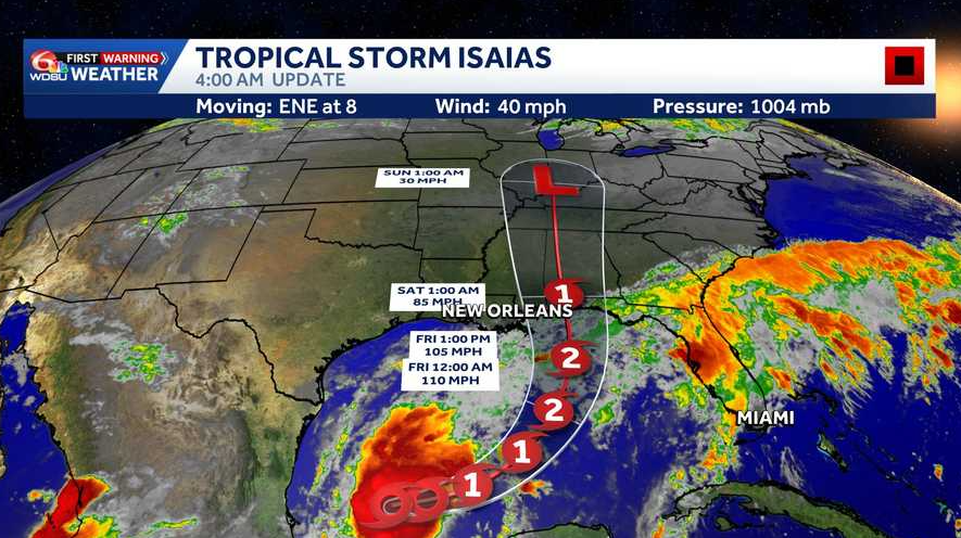
Tropical Storm Isaias Approaches the Northern Gulf Coast
Tropical Storm Isaias has recently formed in the Gulf of Mexico, and predictions indicate a rapid intensification over the coming days, with potential implications for the northern Gulf Coast.
Current Status of Isaias
As of 4 a.m. on Wednesday, Isaias boasts maximum sustained winds reaching 40 mph and is located approximately 580 miles southwest of the mouth of the Mississippi River. The storm is currently tracking east-northeast at a speed of 8 mph.
Forecasted Path and Impact
The National Hurricane Center forecasts that Isaias is likely to strengthen into a hurricane by Thursday and is expected to make landfall along the northern Gulf Coast by Friday. The storm’s trajectory will see it bypassing Mexico’s Yucatan Peninsula before heading toward the Gulf Coast.
Wind gusts associated with Isaias could extend up to 45 miles from its center, leading to dangerous conditions.
Potential Hazards from Isaias
Residents along the northern Gulf Coast should prepare for the following potential hazards:
- Heavy Rainfall: Predicted accumulations may reach between 3 to 6 inches, localized totals could approach 10 inches from southeast Louisiana to the Florida Panhandle.
- Flooding: Both flash flooding and localized river flooding are concerns, with street flooding also possible.
- Severe Surf Conditions: Dangerous surf and rip currents are anticipated along the Gulf Coast as Isaias approaches.
Safety Recommendations
As the storm approaches, it is crucial for residents in southeast Louisiana and surrounding areas to monitor updates closely. Today, hurricane watches are likely to be issued for parts of the northern Gulf Coast.
Officials recommend that residents review their hurricane preparedness plans, check emergency supplies, and stay informed through local weather updates and guidance from the National Hurricane Center.
Alert Days and Monitoring
Due to the expected significant weather impacts, WDSU has designated Friday and Saturday as First Warning Alert Days. The storm’s track and intensity will significantly influence local weather conditions.
Future Updates
The next full advisory from the National Hurricane Center is scheduled for 10 a.m. on Wednesday. Additionally, the Hurricane Hunters are set to investigate the storm to collect further data that could enhance forecast accuracy.
