


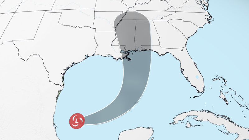
Tropical Depression Nine Set to Strengthen into Hurricane Isaias
A tropical depression, named Depression Nine, is on track to intensify into Hurricane Isaias, threatening heavy rainfall and powerful winds across parts of the southern United States this week. As of Tuesday evening, the depression was situated approximately 600 miles south of the Mississippi River, producing sustained winds of 35 mph.
Forecast Track and Strength
The storm system is projected to move northeast above the Yucatan Peninsula and then shift northward toward the northern Gulf Coast. Predictions indicate that it may escalate rapidly into a Category 2 hurricane, with estimated winds reaching 100 mph by the end of the week.
Potential Impacts
Hurricane Isaias is likely to bring:
- Heavy rainfall, with totals ranging from 3 to 6 inches and localized amounts up to 10 inches.
- Strong winds and storm surge, beginning to affect areas from southern Louisiana to the Florida Panhandle starting Friday.
- The possibility of tornadoes as rainbands impact the coast.
Emergency Preparations
In anticipation of the storm, Florida Governor Ron DeSantis has declared a state of emergency across 25 counties. Residents are urged to develop disaster plans and prepare supply kits. State emergency teams are mobilizing resources such as generators, food, water, and flood barriers in key locations, including Tallahassee and Santa Rosa.
Industry Precautions
Oil companies, including Shell and BP, are implementing safety measures. Shell is evacuating nonessential personnel from six offshore platforms, while BP is securing its operations by sending nonessential workers home.
Weather Conditions Influencing the Storm
This tropical system is functioning under the influence of El Niño, which has historically suppressed tropical activity in the Atlantic this season. While Gulf waters are notably warm, providing essential energy for storm development, the presence of wind shear—a differential in wind speeds and directions—has previously hampered storm organization. The current system is benefiting from lower wind shear in the southern Gulf, although stronger shear is anticipated to greet it as it approaches the northern Gulf Coast.
Final Preparations and Expectations
The exact trajectory and intensity of Hurricane Isaias remain uncertain, causing challenges in predicting flood, wind, and storm surge impacts along the Gulf Coast. Precautions should be taken as the earliest onset of severe weather could begin late Friday or early Saturday.
Historical Context of October Storms
October and November typically witness four named storms, but this varies year-to-year. Past years illustrate this inconsistency, such as the formation of seven storms in October and November 2024 compared to just two the previous year. Late-season storms often emerge closer to the U.S. coastlines, including the Gulf and Caribbean, increasing their potential to impact land.
Looking Ahead
Despite forecasts indicating fewer storms due to El Niño’s influence, history has shown us that significant damage can still occur, even without hurricane-strength systems. Flooding associated with earlier systems this year, like Tropical Storms Arthur and Edouard, have resulted in considerable flash flooding and necessitated emergency rescues.
As residents along the Gulf Coast prepare, it is crucial to stay informed about potential weather changes and updates as Hurricane Isaias takes shape.
