


Upcoming East Coast Storm: A Closer Look at Potential Impacts
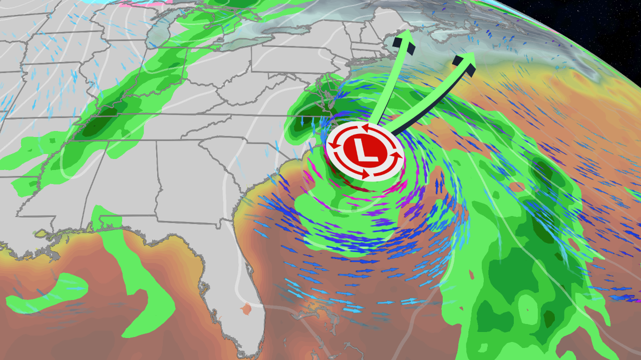
This weekend, an area of low pressure is set to affect the Southeast coast of the United States, bringing with it a forecast of heavy rainfall, strong winds, and the risk of coastal flooding. Following its journey along the Southeast, this storm may intensify and track toward the Northeast by Monday. There are indications it could be designated as Storm Kyle.
Timeline of Development
Forecasters predict that by Friday, low-pressure development will commence off the coast of Florida, likely near the northwest Bahamas. Meanwhile, portions of Florida currently face an imminent flood threat due to persistent rain from a stagnant atmospheric pattern. For specific details on flooding risks, see Florida’s flood forecast.
Impacted Areas in the Southeast
As the low-pressure area moves along or just off the Southeast coast, it is expected to strengthen. This may lead to:
- Widespread rain
- Increased winds
- Coastal flooding and potential beach erosion
States from northeast Florida through the Carolinas, extending into parts of Virginia, could experience these impacts. The exact trajectory of the storm remains uncertain, influencing where wind and heavy rain may occur as the system continues to evolve.
Forecast for the Northeast
As the storm progresses, rain is anticipated to spread into the mid-Atlantic region in advance of its arrival in the Northeast on Monday. Meteorological models suggest significant variability in the predicted path of the low-pressure system—from a trajectory that remains offshore to one that brings it closer to shore, potentially impacting areas from the Delmarva Peninsula to New England.
The eventual path will largely dictate the severity of wind and rainfall in these regions. Currently, highlighted maps indicate areas at risk for heavy rainfall, especially in the darker green zones. There is also the possibility of strong winds leading to power outages and tree damage, particularly if the storm approaches the coastal areas.
Additonally, the full moon on Tuesday will elevate high tides, enhancing coastal flooding risks during peak tides. Travelers looking to schedule flights during the Thanksgiving week may want to prepare for possible weather-related delays, particularly in major Northeast airports.
Why is the National Hurricane Center Monitoring This Storm?
This developing storm poses an interesting situation as it could linger near the warm waters of the Gulf Stream. This condition can help generate showers and thunderstorms that might lead to the designation of a subtropical or tropical storm, depending on its characteristics. The National Hurricane Center (NHC) is closely monitoring this development, with growing chances for classification to happen this weekend.
Potential Impacts and Recommendations
Understanding the storm’s path is crucial for gauging potential impacts. Stay informed for updates from trusted weather sources as the forecast continues to evolve. As of now, individuals are advised to reconsider any weekend beach plans along the Southeast coast due to increased risks of hazardous conditions including rip currents and rough seas.
For more updates on the storm’s trajectory and potential impacts, stay tuned to weather.com for ongoing coverage.
